Digital Environments: Design, Heritage and Architecture
<< Contents
|
Digital Environments: Design, Heritage and Architecture |
<< Contents |
Alan Day and Thom Gorst
Using Computers to Enhance Public Participation in Urban Design
Keywords: CAD, Planning, Public Participation, Urban Design
Introduction
Local government is charged with developing and implementing local and national planning policies through a system that requires a high level of public consultation. This consultation is not easy to implement - it is time consuming, and has to be seen to be thorough and impartial. It often requires those whose views are being sought to manipulate information and use techniques with which they are unfamiliar. This is especially the case with urban design which requires the simultaneous consideration of issues like circulation, massing, overshadowing and architectural aesthetics. Consultation techniques have been developed to allow the general public to participate in these debates in a meaningful way but these are time consuming and have only been used in very particular circumstances. Now, Local Authorities in the United Kingdom are beginning to use the Internet to publicise information relating to the planning process, and there are also examples of interactive urban design. This use of the Internet opens up new opportunities which will make it possible for there to be a much wider debate about how our cities will develop in the future.
The UK Planning System
In terms of urban design, the British planning system has two main areas of activity - local plan formulation and development control. In both of these, there is an expectation that local authorities will consult the public before developing policies and implementing decisions.
Local Plans
Under British planning law, local authorities have a duty to prepare Local Plans, in order to provide a statutory framework for planning applications. The Local Plan summarises local authority policy with respect to the kinds of development it will permit in particular areas. It therefore provides those seeking planning permission with guidance on what is likely to be acceptable. Local Plans are subjected to very lengthy public consultation and thorough scrutiny at local public inquiries. This, in theory, enables all citizens to have an influence on the final content of the Plan. Typically, it might take four years from the publication of the first 'issues report' until a Local Plan is finally adopted. Each stage in the process of adoption allows for consultation and the formal receipt of feedback.
With this demand for greater public involvement, and consequent public 'ownership' of the principles, it has been a central government expectation that landowners and developers will have confidence in the Plan, and that the contents of the Plan will be followed by Local Authorities and planning inspectors in their subsequent recommendations and decisions.
There are difficulties with this. As Healey (1993) has argued, since there is variation within society in the way different social groups perceive and articulate their interests, democratic plans should only have legal status after effective communication with and between each group has taken place, and there should be a recognition of the existence of different systems of meaning within a community. 1
And as Tewdwr-Jones and Thomas have shown, whilst innovative participation exercises aimed at promoting collaboration in the planning process are worthwhile, and can lead to closer working relationships between communities and professionals, the problems caused by legal and policy constraints within the British system often mitigate against translating community concerns into policy development, and this can lead to public frustration. 2
Development Control
Within British Law, the purpose of the planning system is to protect amenity and the environment in the public interest. It operates within the framework of approved Local Plans, so that Councils are able to ensure that development is allowed where it is needed, whilst ensuring that the character and amenity of areas are not adversely affected by new buildings or changes in the use of existing buildings or land.
Once a Local Plan has been adopted it provides the framework for new development. However, the local authority is seldom able to be pro-active in implementing developments envisaged in the Local Plan. Its primary role is to be responsive to the planning applications it receives. This process of development control is the principal way in which the local authority shapes the physical environment of its territory. In theory, if an application conforms to the Local Plan it should get approved but a great deal of interpretation and negotiation has to take place as the Plan deals with general principals whereas a scheme for a specific site is highly detailed.
The development control process tends to be used by the local authority as a way of persuading the applicant to produce the kind of outcome it wants and the negotiation process can be complex and long-winded. These negotiations are carried out by professional planning officers on behalf of the local authority but, in all but the most non-contentious schemes, the decision about whether to grant planning permission is in the hands of the planning committee which is made up of elected councillors. The situation is further complicated by the fact that, if the applicant is dissatisfied with the outcome, they can appeal to the Department of the Environment and the case is then reviewed by a Planning Inspector. In all its decisions the local authority is therefore constrained by the knowledge that it cannot refuse an application unreasonably without risking having its decision overturned.
The Importance of Participation
The planning system is meant to reflect the general wishes of the local community and there is an onus on the local authority to consult widely during the formulation of a Local Plan and in the operation of the development control system. The fact that the Council is made up of elected members ensures a certain level of representation, but wider public consultation is required. When a planning application is submitted the local authority publishes details in the local newspaper and, in some circumstances, a notice is displayed adjacent to the site. In cases of special sensitivity, individual households in an affected area might be canvassed for their opinions or there may be a small public exhibition. However, in most cases, if members of the public wish to find out what is proposed they have to visit the planning department, request the material that has been submitted and examine it on the premises. They can then write to the planning committee if they have any objections.
No matter what the scale of proposal, development control can be thought of as a process of negotiation: at its simplest, between the applicant and the local authority, with only rudimentary involvement by the public. In the most complex cases it involves a prolonged process of 'trading off' between parties, and high-profile public debate.
Not all of the local authority's, or the public's interest in a proposal will be in its visual form: they will also wish to consider its functional content; its impact on the environment (on traffic in particular) and on the local economy. However, we are concerned here with the visual modelling of proposals, and the ways in which the traditional method of depositing plans and physical models is being replaced by digital methods which have the potential to be developed as interactive tools for use in the negotiation process. Our work at Bath has to be seen in the context of the city's special heritage status, and intense public interest in the form and content of all significant planning applications.
Background to the Bath Model
In 1988 the City of Bath was designated as the first World Heritage City in the United Kingdom. It is unique in that its architectural form was established during a period of vigorous expansion in the 18th Century when the city, with its natural warm springs, became a fashionable spa resort. Despite some insensitive demolitions in the middle of the twentieth century, much of this built fabric remains, making Bath one of the best preserved 18th-century cities in the world.
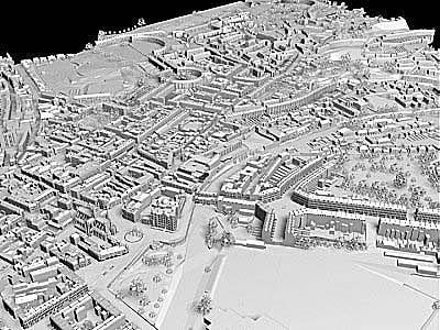
In this context, the Centre for Advanced Studies in Architecture (CASA) at the University of Bath has over the past eight years developed a detailed three-dimensional computer model of the city. It was intended from the outset that the prime purpose of this model would be visualise proposed changes in the city and the local planning authority has worked closely with the project and was instrumental in attracting the initial funding from a private company for the construction of the model. Most of the data for the model came from stereo pairs of aerial photographs, which were used to construct the building geometry and landform. The complete city model was assembled from around 160 sub-models on personal computers using AutoCAD with some in-house program customisation. The central area was modelled in 3D and placed on a 10km x 10km terrain model of the surrounding area, derived from 1:25,000 national Ordnance Survey maps. This allows the city to be seen from the surrounding hills, which in turn form an important part of the vista from the city centre.
Figure 1: General View of the Bath Computer Model
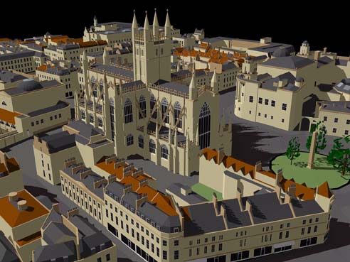
Figure 2: Close-up view of the Model showing the level of geometric detail
Use of the Model
Since it was created the Bath Computer Model has been used in a variety of planning situations. Its first application was on a project undertaken by a local firm of architects to produce a scheme for a sports hall for a school which occupied a sensitive site in front of Lansdown Crescent. Over the past thirty years the school had undertaken a series of uncoordinated building projects and the site was reaching its development capacity. When a new sports hall was proposed the local authority requested a development plan showing how the site would change over the next 15-20 years before it would consider an application for any new buildings.
A number of alternative building locations were identified and schemes worked-up for these sites. This material was then presented to the planners using a variety of techniques, including views of the new buildings generated using the Bath Computer Model and photo-montage views showing the new buildings in their immediate context. This material was used during meetings with the planners and the photo-montages proved to be particularly useful as sensitive views from Lansdown Crescent could be photographed and the new buildings inserted. The computer model was used to generate a long distance view from the other side of the Avon Valley showing the new building in relation to the Crescent. The planners had been particularly concerned about the impact of any new buildings on this view but it was evident from the computer model that their impact would not be significant.
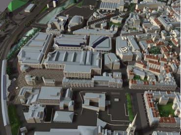
The most recent use of the model has been for a large redevelopment project in the City Centre. The Southgate area of Bath was redeveloped in the 1960s with a large retail scheme, a bus station and a multi-storey car park. This development has never been particularly popular and, as it lies on the route from the railway station to the city centre, it does not provide a attractive approach to the historic core of the city. The shopping centre is on one level with storage above and so the density of the existing development is low making redevelopment at a higher density economically viable.
In 1996 an Action Planning Day was held in Bath, coinciding with a student project held at the Prince of Wales's Institute of Architecture which investigated the future development of the Southgate area. During the day, wall displays showing students' suggestions as to what might be built were mounted on one of the city's most central shopping streets. Shoppers were invited to write comments on labels and to sketch their own ideas - both well-proven techniques in public participation. Over 2,000 comments were received in 5 hours, and the results informed the students' designs. One student's report commented that "We were overwhelmed by the interest taken ... and all subsequent developments of our scheme were made against the backdrop of what the people of Bath wanted to see". Bath Preservation Trust also valued the experience. Timothy Cantell, the chair of its planning committee, commented. "It was good for the Trust to be involved in something as popular and constructive - we are often portrayed as being elitist and negative." 3
In 1998 a new scheme was prepared and, before a formal planning application was submitted, a public exhibition was held in the Pump Rooms in the city centre. Drawings of the proposed scheme were complimented by a traditional architectural model along with a video showing the new buildings inserted in the computer model of the city. The video showed an aerial view of the existing site that dissolved into the proposed scheme. The camera then rotated around the site and paused in order to show before and after photomontages from key street level locations. A particular advantage of this technique is that direct comparisons can be made between an existing and a proposed view thus making it much easier to put the proposals in context.
Figure 3: Aerial view of the proposed Southgate centre
Although the scheme was generally well received, there were still a number of concerns. The aerial view had clearly demonstrated that the new building was much bulkier than its predecessor and that the roof, a key view in a city surrounded by hills, was poorly resolved. This was highlighted by the aerial animation and was one of a number of key issues which led to a comprehensive revision of the scheme, which was formally submitted for planning approval early in 2000.
Developing the Model for Interactive Use
When the Bath Computer Model was originally constructed it was envisaged that the local authority would maintain the model and use it to consider planning applications which have a significant visual impact on the city. In the event the local authority have neither the resources nor the expertise to maintain the model and this has been done by CASA with its use paid for by prospective clients. In some situations, as with a new spa building by Nicholas Grimshaw and Partners, CASA has provided that part of the computer model which surrounds the site so that the architects could use this during the design process and to present the final scheme. One disadvantage of using the model in this way is that the outputs are under the control of the applicant and, if they are paying the bills, they are in a position to exert pressure to make their proposals look as good as possible. It is in the local authority's interest to expose the weaknesses in the scheme and, although they can request that certain views be created, they are not in as strong a position as they would be if they were in direct control of the model.
To date, the use of the model in 'live' planning applications has been limited to pre-rendered animation sequences and photo-montages. Although this is an improvement on more traditional forms of presentation it is still constrained in that viewing positions and animation paths have to be determined before any images are created. This means that users have to anticipate which views are likely to be critical. It would be much better if the model could be viewed interactively so that the user could move the camera position at will and discover how the building might appear from a range of different vantage points. When a planning application is being considered this would give the planners and the public a way of examining a proposal that was not constrained by the preferences of the applicant.
In order to create a view of a 3D computer model some fairly intensive calculations have to be performed. The perspective view has to be established, the way in which objects obscure one another calculated, and the appropriate amount of light and shade allocated to each surface. When the Bath computer model was first constructed in 1993 there was so much detail that it took a sophisticated rendering package 48 hours to create a single view of the city. In order to allow interactive movement a series of views have to be created, ideally 24 a second, although this can drop to around 10 a second before movement appears too jerky. Reducing the rendering time of a frame from 48 hours to one tenth of a second is a considerable task and, although the continuous improvements in hardware performance have had a significant impact on this problem, other strategies have had to be pursued as well.
The most important of these is scene-culling where only those elements which appear in a particular view are rendered and then only at an appropriate level of detail. The Bath model is made up of 160 sub-models, each of which is about one megabyte in size. Each sub-model has been create at four levels of detail so that when a view is created only those models which appear in the view are rendered with the sub-models closest to the camera being rendered at the highest level of detail and those in the distance only being represented by simple blocks.
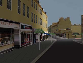
Another strategy that can be employed to speed-up rendering times is to reduce the number of faces in the model. For most architectural purposes it is desirable to have a model that has a high level of geometric detail as this provides relief on facades and gives a high level of authenticity to the roofscape. However, the manipulation of this geometric detail is hard work for the computer and much faster rendering times can be achieved if simpler geometry is utilised with photographic texture maps providing the required level of detail. Indeed, some city models use this technique extensively and can create a very convincing impression of a city by using simple boxes with photographs of the building facades pasted onto them. The model of Los Angeles which has been constructed at UCLA uses this technique to considerable effect. 4 Given the complexities of urban form in Bath, there are limits to how far this technique can be employed, but some elements, such as windows and shop fronts, have been modelled in this way. The shop fronts are particularly useful as they help residents navigate around the model by providing an element of familiarity that is very difficult to reproduce in other ways.
Figure 4: Use of photographic texture maps to reduce the amount of geometry required in the model
When renderings of the model were first produced this was done on a Silicon Graphics workstation which was optimised for high-speed graphics work. Although this is an ideal platform for this kind of application, both the hardware and software are very expensive and such a machine is unlikely to be available in a local authority planning department. It was therefore decided that it would be ideal if the model could be accessed using any computer, from a desktop PC to a specialist machine. Following an investigation of available software it was decided to use the Virtual Reality Modelling Language (VRML) as this had the advantage of running on most Internet browsers, such as Netscape and Microsoft's Internet Explorer. Software was written to convert the Autocad models into VRML and it is now possible to navigate through the model in real-time on a range of computer platforms. The rendering speed varies considerably depending on the machine that is used, but a well-specified PC is capable of allowing interactive movement at about 5 frames per second which is almost acceptable. Although the quality of the image is not as good as can be achieved using specialist rendering software it is acceptable for most purposes and is certainly good enough to allow the user to identify the critical views which can then be rendered to a higher standard if required.
In developing the new VRML software a number of additional features have been included which are designed to assist with the planning negotiation process. Normally when an architect is preparing a planning application a number of meetings will be organised with the planning officers responsible for that area in order to get some feedback on the likelihood of the application being approved. Although this is not a requirement, it provides a valuable way of bringing the proposed scheme into line with current thinking in the local authority and alerts the architect to those issues which are likely to be problematic.
This negotiation process is currently carried out using conventional media, such as drawings and models. The process can be very informal or relatively formal depending on the state of the application and the relationships established between the participants. The outcome is normally a set of suggestions about aspects of the scheme that are likely to be unsatisfactory and these are used by the architect to revise the scheme and produces a new set of drawings. Were it possible to aid this process by providing some interactive design tools there would be significant advantages on both sides. The process could be speeded up and there would be fewer opportunities for misunderstanding between the parties.
To address this a number of interactive tools have been developed for the Bath Model. All of these are accessed from a simple graphic interface displayed on the viewing window of the model and are designed to be simple to use. A non-expert should be able to carry out the manipulation of the model after about 10-15 minutes of instruction.
Addition and deletion of trees and other landscape features
This allows users to select from a palette of objects and insert these into the model. The objects are 2D pictures which have been pasted onto transparent faces which rotate so that they are always at 90 degrees to the camera. This feature is particularly effective with landscape elements and an avenue of trees or a dense area of planting can be considered and then amended very easily. It is even possible to see how the passing seasons affects a proposal as alternative summer and winter versions of various trees have been implemented.
Switching between alternative schemes for a site
This is done relatively simply by having a number of different sub-models available for a particular site. An on-screen button allows the user to switch between these alternative schemes while interactively moving through the model. This allows critical views to be identified and then all the alternative schemes can be examined in order to assess their impact from that position. This is particularly useful fairly early in the design process when different schemes can be represented in block form and their visual impact assessed before undertaking detailed design.
Modifying objects in the model
There are also a series of tools, which allow objects to be manipulated once they are in the model. All computer-aided design packages have sophisticated editing features which allow elements within a model to be moved, stretched or rotated but these features are not normally available in VR software. When undertaking design negotiation during the planning process this level of editing is not appropriate, but it is helpful to have some editing tools so that building heights can be altered and the principal element, which make up a scheme moved around on the site. The first of these tools to be implemented in the Bath Model was a height adjustment slider. The user selects an object in the model by clicking on it and then uses a simple control to adjust its height. Only those objects that have been inserted into the model can be adjusted in this way; the blocks, which make up the existing city are not affected.
This height adjustment tool is not particularly sophisticated and simply stretches an object to a new height. Features are either compressed or elongated and so architectural detail, such as windows and doors, can look rather odd. However, the intention is to provide something that can assist the negotiation process, for example by helping to agree on an appropriate roof height for a proposed building, rather than showing exactly how this new form will be realised. Having reached an agreement the architect can then go away and redesign the building, perhaps by removing an entire floor, in order to comply. Currently under development are additional editing tools which allow objects to be moved and rotated in order to further assist the negotiation process.
Planning on the Internet
Developments on the World Wide Web now allow 3D models to be shared across the Internet and manipulated on any computer. Even so, the ability to process 3D information is still restricted. By July 1998, three London local authorities - Wandsworth, Westminster and Hackney - had started posting current and archive planning applications on the Internet. It is no longer necessary to visit offices in person and search through files to have access to local planning information; it is now possible to conduct searches and to challenge applications from remote on-line locations. 5
The Internet is also beginning to find uses in urban design. The Swiss city of Zwolle recently invited public participation in an urban planning exercise. The city's prime aim was to invite discussion on its own ideas amongst planning practitioners and academics. Their current project for the remodelling of a run-down area dominated by a motorway was published in a 'Virtual 3D Tour', and proposals were invited over the Internet and published alongside the tour as they were received. It is not hard to see how these processes could be applied to planning proposals within the statutory system in cases that incorporate high levels of urban design.
It should be noted that the Zwolle exercise invited involvement from professionals and academics, who would most likely be regular users of the Internet and familiar with the manipulation of built form. We have no experience of the way in which the public generally might benefit from the use of new technology in the conjecture of proposals, so we should first consider how involvement has taken place using 'traditional' tools.
In 1996 the Urban Design Group established a public participation programme to investigate the best ways of involving the public in urban design. Its main findings were published in 1998 and place greatest emphasis on the process of involvement, but the report does not advocate the use of new technology. However, it does catalogue activities that take place in participation in urban design and those that provide opportunities for using modelling are:
- Activity Mapping: getting people to plot how they use places.
- Adaptable Models: a flexible 3D model of an area or building which allows people to test out alternative design options.
- Design Game: Method for devising building and landscape layouts with residents using coloured cut-outs on plans.
- Elevation Montage: Display technique for helping people to understand and make changes to streetscapes. These are usually montaged from individual photographs and mounted at eye-level on a wall.
- Interactive Display: Visual display which allows people to participate by making additions or alterations. They can range from blank sheets with simple one-line questions to drawings or models of complex development proposals.
- Table Scheme Display: Simple way of securing comment on design proposals by taping drawings on a table-top and requesting people to vote with sticky dots. This technique can allow a large number of people to understand and make an input into development proposals with or without engaging with others.
- Visual Simulation: Techniques for showing how buildings will look when constructed using photomontages.
These techniques were generally developed for use in a group situation with all the participants working together in a single space using drawings and conventional models. However they could work as well in virtual space, which would have the benefit of allowing many more individuals to participate. Digital media have an inherent flexibility, which would make the consideration of alternative scenarios much easier to realise.
Developing an Appropriate Technology
The work that has been carried out so far in Bath has concentrated on providing visual material to assist in two stages of the development control process; design negotiation and public consultation once an application been submitted. The work has concentrated on the use of 3D computer modelling techniques to produce images of proposed projects and has now reached the stage where interactive movement through models is possible. Although it may still not be feasible to run very large models across the Internet, text and images are now widely used and small animation sequences are becoming increasingly popular. We would anticipate that within the next three years sufficiently comprehensive 3D models could be run on a personal computer over the Internet to make their use as part of the planning process realistic.
In order to allow non-experts to participate in the planning process two things are needed: access to the relevant information, and for that information to be presented in a form that can be understood easily. The Internet provides a way of achieving increased accessibility and this can broadened even further as more computers are made available in public buildings, such as schools and libraries. The way in which information is presented in web pages has a particular style, which has limited quantities of text and an increased use of graphics. Currently planning authorities are just putting existing material on the web but there is likely to be a shift towards a more graphical approach, driven by the requirements of the medium, which will assist in making the material more easily understood.
Conclusion
In the politics of urban development, visual evidence has traditionally been used to advocate the case of one side or the other in an adversarial process, in which different positions might be taken by developers, interest groups, or statutory bodies. For developers, visual evidence may take the form of an architect's drawing, which may be difficult for the lay-person to understand, or an 'artist's impression', in which viewpoints might be selected, perspectives distorted, lighting exaggerated, and background, details and materials manipulated in order to show a building to best advantage. Used in the right way computer visualisations can provide visual evidence that is to a degree more objective. It can offer variable viewpoints and accurate perspective, and it can allow all parties in an adversarial process the opportunity to work together towards a resolution.
In order to maximise public involvement in the development control process two things are necessary. Information needs to be widely accessible and to be as objective description of what is proposed as possible. This paper has illustrated that computer modelling can help in providing that objectivity but only if the models themselves are under the control of the planners.
For computer modelling to be an effective tool in development control, its use must be defined and supported by legislation. Otherwise, it works solely in the interest of the developer.
In local plan formulation, the Internet offers a simple method for the exchange of information during the lengthy process of public consultation. However, this genuinely democratic development would place a burden on planning authorities, who would have to offer public participants the satisfaction that their responses had been noted and responded to.
We see exciting potential for the Internet in urban design, in cases where there is a perceived need for interaction with the public. The face-to-face techniques in urban design consultation that we listed above can be replaced by remote interaction of participants using the Internet. The issues this raises are not so much technical, as the development of protocols which ensure a satisfactory conclusion is reached, and that those participating have been genuinely involved in the process.
Notes
1 Healy, P (1993), 'The Communicative Work of Development Plans', Environment and Planning B, pp.83-104, vol 20.
2 Tewdwr-Jones, M and Thomas H, (1998), 'Collaborative action in local plan making', Environment and Planning B, pp.127-144, vol 25.
3 Hall, A C (1993), 'The Use of Computer Visualisation in Planning Control', Town Planning Review 64 (2), p.193.
4 Evaluation Report, Bath Planning Action Day, Urban Design Group 1996
5 Special Report: Public Participation Programme; Urban Design Quarterly, Issue 67, July 1998