Digital Environments: Design, Heritage and Architecture
<< Contents
|
Digital Environments: Design, Heritage and Architecture |
<< Contents |
Tim Sharpe and Ian Pickering
The St Avit Project
Keywords: Architecture, Medieval, Romanesque, CAD, Web-based-research
Introduction
The St Avit Project is about the Abbey and Church of St Avit Sénieur in the Dordogne in the SW of France. This project started with a simple proposition. That the questions about the previous form of the Abbey of St Avit Sénieur could be examined and, perhaps resolved, by the virtual reconstruction of the Abbey using digital techniques - the building of a computer model.
Included in this proposition was the idea that the accuracy that would be required to build the model would contribute to this investigation - particularly in the examination of three dimensional elements and the way in which they come together. I had in mind the idea that the careful measurement of beam sockets and arch springings - the architectural equivalent of the dinosaur's bone - could be used as the same kind of forensic tool.
When Tim Sharpe joined the project he made a further proposal, which developed the idea, the information that was collected, could be stored, collated, and disseminated using digital techniques. We could use the web as a means by which others could become involved in the research and that the research could develop enriched strands and directions as a result of particular interests of those who became involved and, what is more, we could develop a means by which research could be carried out in the field using resources that could be accessed by the web.
The information we collected and organised would also become a resource available to anyone to use and something that might develop its own momentum undirected by us.
So the project has developed three strands of enquiry.
1) That we can investigate ideas about the Abbey's form through the reconstruction of the Abbey using information collected on site - dimensions, levels, details.
2) That we can investigate the use of the web as a means of acquiring expertise on site without the physical presence of the experts and that we could access resources that would not be available in the field.
3) That, in making the information available, we can record and investigate how far this will stimulate further participation from anyone who might be interested in contributing their knowledge and experience to our research on St Avit but also how far this will generate new lines of enquiry independent of the research concerning the Abbey and Church at St Avit.
Before discussing what we have done so far, it is important to say that this project is still at an early stage. We should also give some indication of what it is that makes St Avit an interesting subject for such research.
In the first place the church is currently being renovated by the architects of the Monuments Historiques, which gives us access to parts of the building as work progresses but also means that we are, to some extent, dependant on the pace of the work in carrying out our measurements.
There is another point about measurement. The drawings we received from the Monuments Historiques are from a range of sources and are not always consistent although they are perfectly good for the purposes for which they were made. In addition we found that some of our measurements did not tally with those shown on the drawings.
As we did not have access to all parts of the building, the plan we eventually generated became the best compromise we could make. It also pointed up the value of field information - that the work of reconstruction might best be carried out on site where you can go and check dimensions or that the information collected has to be capable of being confirmed if possible. The use of pencil to record measurements should be avoided!
We should also mention that, last year, the project provided the students involved with source material for their measured study. This provided considerable detailed information and is something we hope will continue.
Why St Avit?
The Abbey was a pilgrimage site and contains the remains of the saint Avit. Avitus was a soldier in the Visigoth army of King Alaric in the 5thC. He was captured by the Franks when Clovis the Frank acquired Aquitaine by defeating Alaric at the battle of Vouillé in 507.
Avitus was sold as a slave in Paris but he must have been well born because he was converted to Christianity by Clothilde, wife of king Clovis. He had a vision and returned to Périgord, preaching and performing miracles on the way which made him famous. He became a hermit, living in a cave near St Avit Sénieur.
St Avit Sénieur is also en route to Santiago de Compostella in northern Spain but not on the major route through the region, so St Avit was a pilgrimage centre from the 7th century to the high middle ages although the Abbey is 11th century and St Avit's remains were not translated there until 1118.
There are some interesting questions about its position. Particularly as many of the surrounding onward destinations are 13th century and would not have existed when St Avit Sénieur was built. One line of enquiry could involve the creation of an interactive map relating to these settlements and routes.
The key question, however, arises from the date and location of the existing church. The date because it is Romanesque and its location places it among a singular group in SW France with domes over each bay of the nave. A style known as Byzantine Romanesque.
The church at St Avit Sénieur does not have domes - it now has vaults and there has been much argument about whether the domes were ever built and, if they were built, why they were replaced.
We cannot refer to records as the Abbey was sacked in 1577 and all of its records destroyed. Consequently, there are only the records on the Abbey itself incised in the fabric, or the evidence that can be deduced from the remains and the existing fabric.
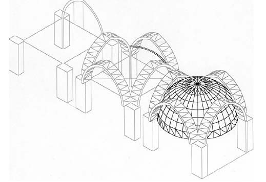
There are some photographs taken at the time of repairs and excavations carried out in 1969, particularly of the vaults uncovered during the repairs. 1These show a ring of stones at the base of the vaults indicating that the domes were at least planned but also show that the vaults are groined domes rather than web vaults. The construction of these vaults became of interest as webbed vaults would have a crease at the rib but these vaults appeared to be domical.
I tried a very simple experiment based on the idea that the stones forming the ribs would be a regular shape if they followed a semicircular section as they would if the vault was hemispheric.
I made the assumption that the diagonal ribs would be semicircular and rotated the arch of the semicircular rib to form a dome. Because the side and cross arches are pointed rather than semicircular, I expected the dome not to fit at the apex of the arch but I was surprised at the extent to which it did not. In fact I had the arch dimensions checked twice to confirm the difference between these measurements and the arch profile shown in the section drawings in our possession.
[Figure 1 to be inserted here]
Figure 1: caption
Figure 2: Vault experiment showing construction of arches and dome
Figure 3: Apse experiment showing reconstructed arch and arch projected to form semicircular apse
The second experiment established an apex for the vault, a circle at the point of intersection of the ribs with the arches and constructed an arc to the point of the springing of the vault at the corner of the piers. This had to be adjusted to fit and shows that the diagonal ribs are not a regular curve. This has implications for the centring and construction of the vaults and has yet to be explored or, indeed confirmed, but it does seem to illustrate a value in a simple three dimensional construction that seems only possible through computer modelling.
It also reveals two curious relationships to the work of the medieval mason in that the construction of the computer model poses the same problems of locating a point in space and making a construction to it and the building of the model uses templates for mouldings and extrudes them, which is a masonry technique.
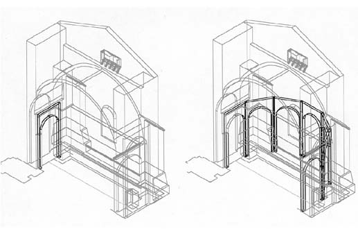
The model that we propose has been started at the East end where it is said that the existing church was started but this is more to do with the progress of the renovations which also started at this end.
This end is in fact a repair after the original semicircular apse was destroyed in, it is thought, 1577 during the sack of the Abbey. There are some remains of the original apse in part of a blind arch which is thought to have been part of the form of the original apse and which can be extended to make a complete arch and reproduced in the reconstruction of the semicircular apse as a series around the apse. To do this well will require rather more detailed measurement than we have recorded so far but we have enough information to make an initial apse model. (fig 3)
These models have been constructed using AutoCAD but there is another model being constructed using ArchiCAD which is intended to show the overall three dimensional form and levels for reference. This is the result of preferences for PCs or Macs. It is a relief that data can be transferred.
There have, so far been two research visits to St Avit Sénieur. The first year collected a considerable amount of survey information but it became apparent that some of this would have to be confirmed during our visit this year and we began to investigate the use of more sophisticated methods, including the use of digital photogrammetry.
We have made a proposal for support for the use of digital photogrammetry in conjunction with the Dept. of Geography and Topological Science at Glasgow University and hope that we will be able to exploit these techniques next year.
This year we had at our disposal, laser levelling and laser distance measuring equipment, digital cameras and digital video with two Mac laptops and one PC based laptop and a modem connection to the web. There were six students and we had a house within walking distance of the Abbey with facilities at the Abbey for storing equipment and access to the site and scaffolding. Much of the work this year involved the building of a web site for which Tim Sharpe was primarily responsible. I had been able to draw most of the plan and this was rapidly completed on site and became the reference for the information on the web site.
All of this information was prepared in the field during the visit and we were able to acquire and feed information into the site as it was being prepared. Again, it is important to state that this site is at an early stage of its development and is intended to be developed to be increasingly interactive and cross-referenced to give an increasing depth of information and detail.
I should also say that the connection is assumed to be to an academic site rather than a single modem connection (and with a minimum 15" screen). The amount of information will be considerable and require fast download capability.
As I said earlier, this information is the result of access provided by the current work and may not be available again and may be thought as providing an archive of the repairs. This is not and was not, our original intention. Nonetheless we are able to record some evidence of the progress of the work although this is limited to the brief period we are there. It should also be said that the gathering of the information can be, at times, a little hairy.
So what we have is intended as an information store and an information exchange, providing information which can be transmitted to chosen addresses or captured by interested parties and which might be transferred for use by other disciplines and used as a reference for interactive discussions.
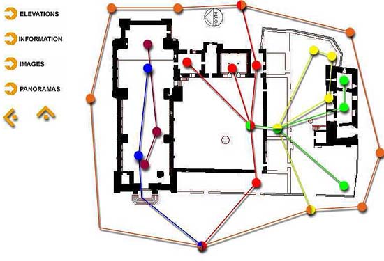
Opening the site you are presented with basic information and a plan which can be used to access the next level. (see fig 5 - shows initial plan with access to panoramas)
This has four options at the moment, the simplest is probably images.
Figure 5: Plan of Abbey showing centre/change points for panoramic images
Figure 6: zoom view of an image
It is a constant that the plan is used as a reference where it is useful to locate a view. In this case not all of the reference pointers are active.
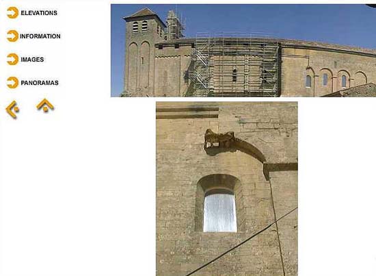
Images range from straightforward views to views taken, for example, from the scaffolding of the remains of the wall or the tower before it was scaffolded this year, distant views and quite detailed views. these images are not yet interactive.
Information provides text and images. These are not yet carefully matched to the text and they are also to become interactive rather than passive. Some information is still quite slight - reflecting our focus on the church. Some might also be expanded in size and ordered in sequence. These are things still to be done.
The elevations provide information of two kinds - scanned images from a variety of sources and digital images taken on site, some of which are composite - an advantage of the technique.
The scanned images are of two kinds - historic records and drawings by the Monuments Historiques.
The digital images provide more information from click points, leading to a more detailed image of the part. This will be developed in more detail as the site is developed.
The plan shows a series of centre points for panoramic images which also act as change points from one panorama to another.
The plan acts as a constant reference showing the direction of view at any time as well as indicating change points which can be chosen from the plan. One can also change the image centre from the panorama. (fig 5)
One of the most valuable aspects of the panorama is its ability to provide images of spaces that are not accessible, the roof images for example. One can also zoom into and out of the images. Something we hope to exploit as a means of finding and examining detail. That one can change centres also enables moves from inside to outside.
It is clear that focused detail and wide angle images would be a useful addition to the use of panoramic images. We also hope, in future, to include both generated and video walk through sequences as part of the information bank.
It is too early to draw too many conclusions from this work. It is clear that the use of techniques needs a clear head in understanding its value and purpose. It is still to be determined whether the detailed and accurate reconstruction of the Abbey is of more value than a reconstruction that resolves differences and is less accurate.
It is also clear that, if the work of recording the Abbey is to be of general value it will have to contain some redundency in the collection of detailed information which may, or may not be of value. On the other hand we can respond to requests for information and this may be the way in which this might be resolved.
There is, perhaps only one further thing to add which is our web address which is, for the moment, www.gsa.ac.uk/architecture/stavit99.
Watch this space.
Notes
1 Fitte, P. (1991), 'L' Abbaye de St Avit Sénieur', Vielles Eglises de Périgord, 1, pp.29, 33.